 |
||
|
|
||
 |
|||
|
On a map of the world, the Hawaiian Islands are barely a speck in the 64 million square miles of the Pacific Ocean. But oceanographers recently discovered that these tiny dots on the map have a surprising effect on ocean currents and circulation patterns over much of the Pacific. In the Northern Hemisphere, a system of persistent winds blows from northeast to southwest, from North and South America toward Asia, between the equator and 30 degrees north latitude. These northeasterly winds were dubbed the “trade winds” by ancient mariners who used them for trade voyaging. Typically, the trade winds continue on an uninterrupted course across the Pacific — unless something gets in their way, like an island. Although many people associate Hawaii with flat, sunny beaches, the elevation of the major Hawaiian Islands generally exceeds 3,200 feet (1,000 meters). Mauna Kea and Mauna Loa on the island of Hawaii (commonly referred to as “the Big Island”) both tower nearly 14,000 feet (about 4,300 meters) above sea level. In addition, Mount Haleakala on the island of Maui stands at over 10,000 feet (3,055 meters) high. Hawaii’s high mountain landscape presents a substantial obstacle in the path of the trade winds. The elevated topography blocks the airflow, effectively splitting the trade winds in two. This split causes a zone of weak winds, called a “wind wake,” to form on the leeward side (away from the wind) of the islands.
“If there were no mountains on the Hawaiian Islands, then nothing would
happen. The trade winds would just blow smoothly across the ocean with
no effect,” said Shang-Ping Xie, professor and researcher at the
University of Hawaii’s International Pacific Research Center and
Department of Meteorology. |
October 2, 2003

Hawaiian Islands image in title graphic courtesy of the USGS |
||
|
The finding that a small island chain can have such a great impact on the Pacific Ocean is significant to the future of ocean observation, Xie said. “If you look at a large region of the Pacific Ocean, you can barely see the Hawaiian Islands. But if you look at the winds or currents in that region, you can clearly see the influence of the Hawaiian Islands. It’s very pronounced.” According to Xie, conventional theories indicate that an island wind wake effect should dissipate within a few hundred kilometers and not be felt in the western Pacific. But Xie and his colleague Timothy Liu, senior research scientist at NASA’s Jet Propulsion Laboratory, discovered a very unusual wake west of the Hawaiian Islands — one that extends 3,000 kilometers, which is roughly 10 times longer than any wake observed elsewhere. |
Mauna Kea, a dormant volcano, looms over the island of Hawaii, the largest member of the Hawaiian Islands. Image Copyright © Laurie J. Schmidt, 2003. All rights reserved. | ||
 |
|||
|
“We started seeing a very long tail trailing the Hawaiian Islands for 3,000 kilometers. We’d never seen such a thing before, so that motivated us to dig deeper for an explanation,” Xie continued. “Aerodynamic theory tells us that the ‘island wake effect’ should continue for no more than a few hundred kilometers. No way would you expect to see this effect for 3,000 kilometers.” “This finding presents a completely different view of ocean-atmosphere interactions in the Pacific. It’s something that nobody has seen before,” said Liu. Xie, Liu, and colleagues noticed the long wake while analyzing data from NASA’s QuikSCAT satellite, which uses microwave radar to measure winds near the ocean surface. They then confirmed their finding with data from the TOPEX/Poseidon and Tropical Rainfall Measuring Mission (TRMM) instruments. QuikSCAT and TOPEX data are available from the Jet Propulsion Laboratory Physical Oceanography Distributed Active Archive Center (PO.DAAC), and TRMM data are archived at the Goddard Space Flight Center Earth Sciences (GES) DAAC.
They also discovered that the wind wake drives an eastward “counter
current” that brings warm water 8,000 kilometers from the Asian coast
to Hawaii. This warm water drives further changes in wind, allowing the
island effect to extend far into the western Pacific. |
The
SeaWinds sensor on the QuikSCAT satellite captured this image of the
Hawaiian wake in August 1999. Trade winds blow from east to west,
intensifying between the islands and weakening in the islands’ wakes. Click here for more information. (A new browser window will open.)
For more information, visit: (A new browser window will open for each.) |
||
|
“It’s logical to think that water would flow in the same direction that the winds blow,” said Liu. “But this current is actually going in the opposite direction — against the trade winds and back towards Hawaii.” “The current may actually extend all the way to the Asian coast, which is about a quarter of the Earth’s circumference,” added Xie. According to Liu, the counter current had been observed by oceanographers near the Hawaiian Islands years before the long wake was discovered. “Drifting buoys off the coast of Hawaii routinely measure currents,” he said. “So researchers were able to document the existence of a current that goes against the trade winds, but they didn’t know exactly what the mechanism was.”One theory, according to Xie, was that the force of the ocean current hitting the islands generated eddies. “It’s like the story about the blind man feeling the elephant,” said Liu. “When he felt the leg, he thought it was a tree. So Japanese oceanographers would see a little part of the current here, the Hawaiians would see another part there, but they did not have a complete picture of what was happening. Satellite data enabled us for the first time to see the whole process across the Pacific, linking what people know in Asia with what people know in Hawaii.” “The fact that separate measurements by three independent satellites come together and fit into a physically consistent picture gives us confidence in our results,” Xie and colleagues said in a paper published in an issue of Science. Xie cited a number of reasons why this phenomenon has only been observed in Hawaii. First, because the ocean reacts slowly to fast-changing winds, the wind system must be steady to exert forcing on the ocean, as is the case with the trade winds. Second, the high mountain topography of Hawaii provides a significant disturbance to the winds. Third, the Hawaiian Islands are large in horizontal scale, extending over four degrees in latitude. “It is this active interaction between wind, ocean current, and temperature that creates this uniquely long wake west of Hawaii,” Xie said. |
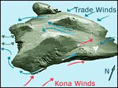
 Prevailing trade winds and Kona winds blow in opposite directions around the mountainous island of Hawaii. Image courtesy of Volcanic Air Pollution — A Hazard in Hawaii from the USGS (A new browser window will open.) |
||
 |
|||
|
The researchers’ discovery of the long wake testifies to the strong interaction between the atmosphere and ocean, which has strong implications for global climate research. “The strength of ocean-atmosphere interaction revealed in the Hawaiian wake helps us assess climate sensitivity, namely how much increase we will observe in the global mean temperature as we increase carbon dioxide levels,” said Xie. “It’s also important for understanding natural climate variations, like El Niño.”
According to Xie, the finding has important implications for models
that predict the Earth’s climatic future. “There are a lot of
uncertainties in existing models,” said Xie. “The vast Pacific Ocean
has been poorly measured until now because there are only a few ships
at sea at any given moment. We need to be able to reproduce this long
wake effect in a model, and this can only be done with high-resolution
satellite data. The discovery of this far-reaching effect of tiny
islands demonstrates the huge potential for observing the oceans from
space, and for even more surprising discoveries. |
This tree grows near South Point, the southernmost tip of the island of Hawaii. The trade winds that continually blow across the island cause it to be permanently bent in one direction. Image Copyright © Laurie J. Schmidt, 2003. All rights reserved. | ||
|
“A lot of people can’t even locate Hawaii on a map,” Xie concluded. “So, in that sense — it’s very surprising that an almost invisible geographic feature can have such a profound effect on the ocean-atmosphere system.” Xie, S.-P., W.T. Liu, Q. Liu, and M. Nonaka. 2001. Far-reaching effects of the Hawaiian Islands on the Pacific Ocean-Atmosphere System. Science. 292(5524):2057-2060.
This article contributed from Distributed Active Archive Center (DAAC) Alliance: Supporting Earth Observing Science 2003 |
This picture of the Hawaiian Islands was taken from the Shuttle Discovery in September 1988. Although some volcanic aerosols can be seen blowing downstream from the island of Hawaii (the Big Island), the clouds and surface water patterns in the wake of the other islands show how far downstream the island wakes persist. Image courtesy of The Gateway to Astronaut Photography of Earth from NASA Johnson Space Center (A new browser window will open.) | ||
| NASA Earth Science Enterprise Data Centers provide data and user services in support of the Earth observing sciences. For other articles about the data centers, visit the Earth Science Enteprise Feature Stories list. |
|
Subscribe to the Earth Observatory
About the Earth Observatory Please send comments or questions to: eobmail@eodomo.gsfc.nasa.gov Responsible NASA official: Yoram Kaufman NASA/GSFC Security and Privacy Statement |